PROGRAM
Looking for an unforgettable adventure in the Alps? Join us on the Spaghetti Tour on Monte Rosa with a IFGMA-certified Mountain Guide!
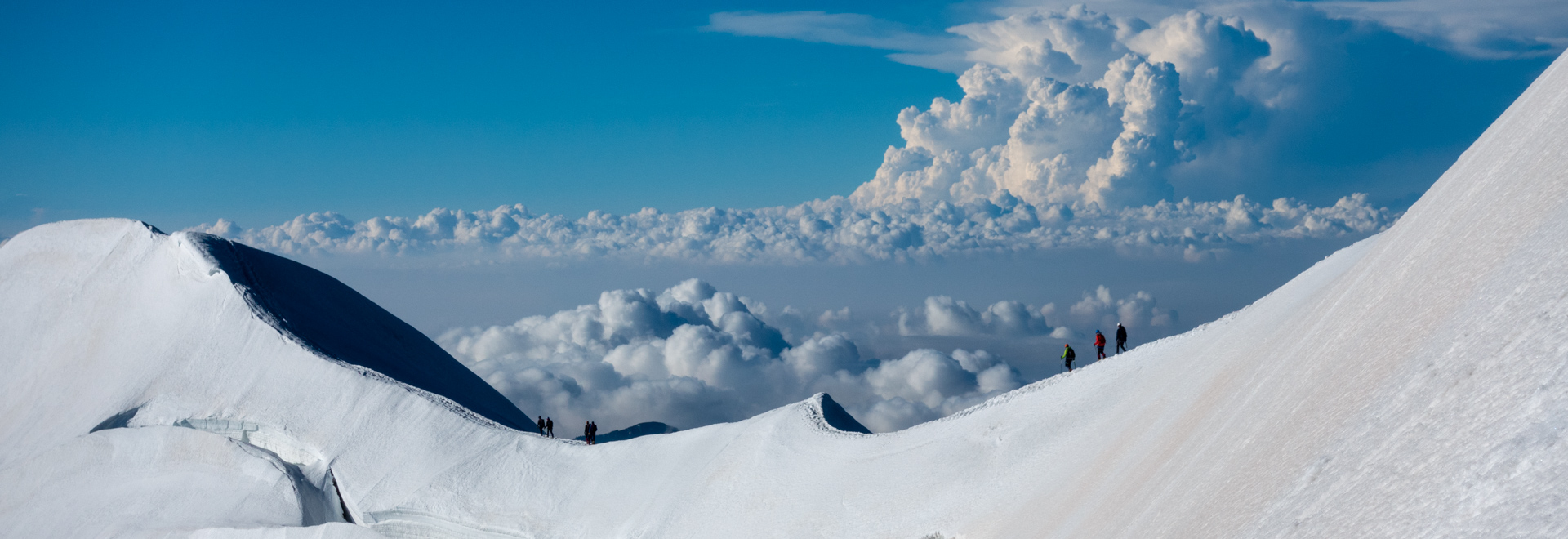
This Monte Rosa traverse lasts 5 days, during which we will climb one or more 4.000-meter peaks each day. This makes the Spaghetti Tour a unique itinerary, with ascents of iconic peaks such as the Breithorn, Lyskamm Nose, Castor, Vincent Pyramid, Signalkuppe, Balmenhorn, Ludwigshöhe and Zumsteinspitze.
The adventure is suitable for fairly experienced mountaineers: you should have already reached mountaineering peaks and be familiar with rock passages, climbing and glacier progression with crampons. Above all, you should be in good physical shape: the 5 days are challenging and requires physical endurance so as not to be over fatigued.
Among the Monte Rosa huts: hospitality and good food
During the Spaghetti Tour we we will spend 4 nights in the most fascinating mountain huts of Monte Rosa:
- First night at the Guide di Ayas Hut
- Second night at the Quintino Sella Hut
- Third night at the Gnifetti Hut
- Fourth night at the iconic Margherita Hut
Note that by choosing Peakshunter Mountain Guides you are also choosing the quality of our service: we will take care of all half-board hut reservations, which means breakfast and dinner are included in the rate. You won’t have to worry about anything, just enjoy the Spaghetti Tour!
Spaghetti Tour: dive into the history of mountaineering
“Spaghetti Tour” is the name given by English-speaking climbers to a traverse of the Monte Rosa group starting in Cervinia and ending in Gressoney. During the itinerary, in fact, the first climbers stayed in Italian refuges and, of course, they recovered their strength by eating pasta and spaghetti! Also, our traverse follows in the footsteps of the competition route of the Mezzalama Trophy, one of the oldest and most famous mountaineering competitions in Europe, with the first edition in 1933.
Ready to go? Get in touch with us!
If this Spaghetti Tour mountaineering tour may be right for you, please feel free to contact us by submitting the form on this page. We will contact you to answer any questions and plan the details of your trip. Please note that you can join an open group on the scheduled dates, or you can arrange your own tour privately. In both cases the guide ratio is 1:3, which means that each guide can take a maximum of 3 people.
GROUP DEPARTURES
Elevation gain: 700 m
Ascent/descent time: 5-6 hours
Meeting point: Cervinia cable car ticket office for an equipment check and a briefing with the Guide
We take the cable car to Plateau Rosa, then we climb up to the Breithorn Pass and after to the summit of Breithorn (4.165 m).
A quick descent take us to the trail that running under the Central Breithorn, the Roccia Nera and Pollux, leads right up the Verra Pass. From there, in about an hour we descend to Guide di Ayas hut (3,400 m).
Elevation gain: 800 m
Ascent/descent time: 6-7 hours
We make our way up to the Verra Pass, which marks the start of the route up the west face of Castor. At around 4,000 m, having negotiated the bergschrund, we tackle the climb to the summit ridge. The view from the summit of Castor (4,200 m) is magnificent, ranging from the Margherita Hut to the Lyskamm, from Gran Paradiso to Mont Blanc and from the Po Valley to the Swiss four-thousanders.
The descent begins with a pleasant, and fairly easy walk along a snowy ridge, which leads to a steep slope that take us down to Felik Pass and Felik Glacier.
At 3,575 m, at the edge of the glacier, we arrive at Quintino Sella Hut, where we can enjoy a meal and stay the night.
Elevation gain: 800 m
Ascent/descent time: 6-8 h
For the first two hours we walk along the Western Lys glacier, then we are faced with the steep climb to Lyskamm Nose. A fairly easy descent leads us to the Eastern Lys glacier, which we cross heading towards Vincent Pyramid. Having reached the summit, we take the trail that coming down from the Lysjoch and make our way to Gnifetti Hut (3.647 m) where we enjoy a meal and stay the night.
Elevation gain: 1,500 m
Ascent/Descent time: 6-7 hours
This lap takes us to the highest mountain hut in Europe, Margherita Hut (4,554 m).
It is a gradual ascent that touches the summits of Balmenhorn, Ludwigshöhe. Finally, we reach Signalkuppe, where Margherita Hut stands, where we enjoy our meal and stay the night.
Elevation gain: 100 m
Elevation loss: 1,680 m
Ascent/descent time: 6-8 hours
We leave Margherita hut to reach the last of summit over 4,000m, Zumsteinspitze . From here, downhill all the way to Gressoney.
From here we will take a taxi to Breuil-Cervinia.
Elevation gain: 100 m
Elevation loss: 1,680 m
Ascent/descent time: 6-8 hours
We leave Margherita hut to reach the last of summit over 4,000m, Zumsteinspitze . From here, downhill all the way to Gressoney.
From here we will take a taxi to Breuil-Cervinia.
DETAILS


RATES
- the assistance of a UIAGM/IFMGA certified Mountain Guide
- the Mountain Guide’s expenses (lifts, transfers, meals and accommodation)
- liability insurance
- safety gear used by the Guide (eg rope)
- loan of personal equipment (harness, ice axe, crampons and helmet)
- overnight stay in a refuge with half board
- tickets for lift facilities
- booking assistance service (including assistance for refuges and lifts reservation)
The rate does not include
- research and rescue insurance with UVGAM coverage (recommended): €12 per person for 7 days
- transfers
- extra meals and beverage for customers and the guide
- anything that is not mentioned under "The rate includes"


