
PROGRAM
Only for experienced and well trained mountaineers, this is the most scenic and also the most difficult route. Witha drop of 1,800 m among breathtaking glaciers and sharp ridges, the route wind through the most untouched corners of Mont Blanc’s south face. Opened downhill by Achille Ratti in 1890, it subsequently became the Normal Italian Route. Nowadays it is a demanding and seldom-attempted itinerary, in a high mountain environment of unmatched beauty.
The ascent from the Normal Italian Route, less frequented and technically more difficult, involves significant physical efforts and necessarily requires high technical skills, as well as previous experience in mountaineering, excellent training and a good endurance to sustained efforts at high altitude: a mountaineering curriculum is therefore required to be able to better evaluate the technical level before the trip.
In any case, the Guide often asks customers to add at least one day of acclimatization, aimed at evaluating the customer’s technical abilities and their confidence in using crampons on itineraries with challenging slopes and exposures.
Note: due to weather conditions, in recent years it has usually been accessible only in the first part of the season, when there is still enough snow coverage in the lower sections. Take a look to Goûter Route for an easier ascent.
GROUP DEPARTURES
Elevation gain: 1,400 m
Ascent time: 4-5 hours
Meeting point: meeting in Courmayeur for equipment checking and shortbriefing.
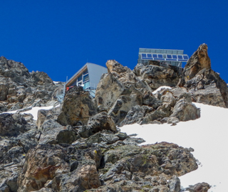
We’ll start at the bottom of Veny Valley, we will walk on a paved road until Combal lake. From there we’ll climb the steep moraine up to the sharp rocky ridge, towards the Miage basin. We’ll walk for about 2 1/2 hours on the glacier’s moraine, on flat ground, in a truly spectacular setting. During the final stretch, detritus gives way to snow and ice. The last part of the ascent, on a steep but fully-equipped trail, will take us to the Gonella Hut (3,050 m).
Dinner and overnight stay in the hut.
Elevation gain: 1,400 m
Ascent time: 4-5 hours
Meeting point: meeting in Courmayeur for equipment checking and shortbriefing.
We’ll start at the bottom of Veny Valley, we will walk on a paved road until Combal lake. From there we’ll climb the steep moraine up to the sharp rocky ridge, towards the Miage basin. We’ll walk for about 2 1/2 hours on the glacier’s moraine, on flat ground, in a truly spectacular setting. During the final stretch, detritus gives way to snow and ice. The last part of the ascent, on a steep but fully-equipped trail, will take us to the Gonella Hut (3,050 m).
Dinner and overnight stay in the hut.
Elevation gain: 1,800 m
Ascent/descent time: 10-12 hours
We’ll leave the refuge around 1 am and tackle the glacier, alternating upright slopes, flat stretches and some steep pitches on seracs. The extremely wild landscape stretches until the plateau under the Col de Bionassay, which we’ll traverse towards the Col des Aiguille Grises (heavily crevassed and difficult). Before the climb, we’ll take a breather on the bare ice with some easy rock stretches (pitches up to grade II). From the Col des Aiguille Grises (3,900 m), we’ll ascend the sharp and spectacular ridge, with airy and narrow stretches giving way to the ample slopes leading to the summit of the Piton des Italiens. Without further difficulties we’ll reach the peak of the Dôme du Goûter, where our route joins the Goûter (French) route (4,200 m).
From here we’ll pass by the Vallot Hut (4,362 m) and finally, along the amazing Arête des Bosses, we’ll reach the summit.
We’ll go down along the same route down to Gonella hut; dinner and overnight at the hut.
In case the conditions (for weather or timing reasons) require the descent on the French side, the Guide will decide to descend along the route best suited to ensure safety (Gouter/Tête Rousse or Cosmiques /Torino hut route), with use of cable car for the descent to Chamonix or Courmayeur.
The return to Italy, in this case, must include an extra cost for the purchase of lift tickets and private taxi transfer for the client and the Guide. These additional costs shall be covered in full by the customer.
Elevation loss: 1,400 m
Descent time: 4-5 hours
Wake up, around 7:00 am, and breakfast at Gonella hut. We will then follow the same itinerary we climbed up on the first day, until reaching the parking lot in Val Veny.
Lunch break and final toast with the Guide before heading home.
Elevation loss: 1,400 m
Descent time: 4-5 hours
Wake up, around 7:00 am, and breakfast at Gonella hut. We will then follow the same itinerary we climbed up on the first day, until reaching the parking lot in Val Veny.
Lunch break and final toast with the Guide before heading home.
DETAILS


RATES
- the assistance of a UIAGM/IFMGA certified Mountain Guide
- liability insurance
- safety gear used by the Guide (eg rope)
- loan of personal equipment (harness, ice axe, crampons and helmet)
- overnight stay in a refuge with half board
- the Mountain Guide’s expenses (transfers, meals and accommodation)
The rate does not include
- research and rescue insurance with UVGAM coverage (recommended): €5 per person for 3 days
- transfers
- hiring of the trek poles (15€/per person)
- extra meals and beverages
- anything that is not mentioned under "The rate includes"


